Geoglyphology |
During the Foundations research it was discovered that ancient civilizations have passed down a secret science which we have named Geoglyphology. There exists a legacy of geoglyphs, "geo" meaning earth and "glyph" meaning writing, on the shores and highlands of land masses around the world. A well known example of a geoglyphic survey marker is Stonehenge in England. Stonehenge has been known for centuries, as have earlier monoliths, for the many astrological alignments that were designed into their construction. This phenomenon of astrological alignment is present in most megalithic and geoglyphic structures around the world and has recently been accepted as a legitimate science, having been named Archaeoastrology. Until now the geoglyphic attributes of these structures and geoglyphs have been overlooked and known only to a few people in secret societies.
The practice of marking territories with geoglyphs has been passed down secretly for millennia. Since the practice of Geoglyphology is to mark a claimed territory the practice would inherently require some degree of secrecy. Most of these survey markers are so large and so spread out, that most remain hidden unless someone that knows of their existence points them out. By being so large they are, for the most part, immune to tampering and remain hidden, until the builder needs to prove their prior claim to a given territory.
Until now the majority of the information available to the Archeologist has been gleaned from information recovered at a dig site. During our research we realized that a great majority of the ancient architectural, monolithic and geoglyphic structures built around the world had something more to offer. There exists a commonality in that the structures, and associated geoglyphs, were aligned in such a manner that the study of their linear alignment unveils a much larger story and immensely expands the data available to the archeologist, historian, and the related disciplines.
Extensive research on these geoglyphs, which exist on every continent and many islands around the world, have shown that no matter when or where they were constructed they all tie into a worldwide network of civilizations that have progressed, prospered and suffered setbacks for millennia. These geoglyphs range in age from before the 32,000 year old Bosnian Pyramid, to geoglyphs in the United States as late as 100 years ago.
Data recovered from geoglyphs can include obtaining the geographical range of the culture being studied, the level of sophistication that existed in relation to their understanding of mathematics and geometry, their knowledge of world geography, the discovery of other archeological sites that were unknown prior to the studies, and the dating of the culture itself by the data collected at the offsite locations and the sophistication of the geoglyphs.
What makes up a Geoglyph?
Glyph - A glyph can be any design that is used to convey a message.
Geoglyph - A geoglyph is a glyph that occurs on the ground.
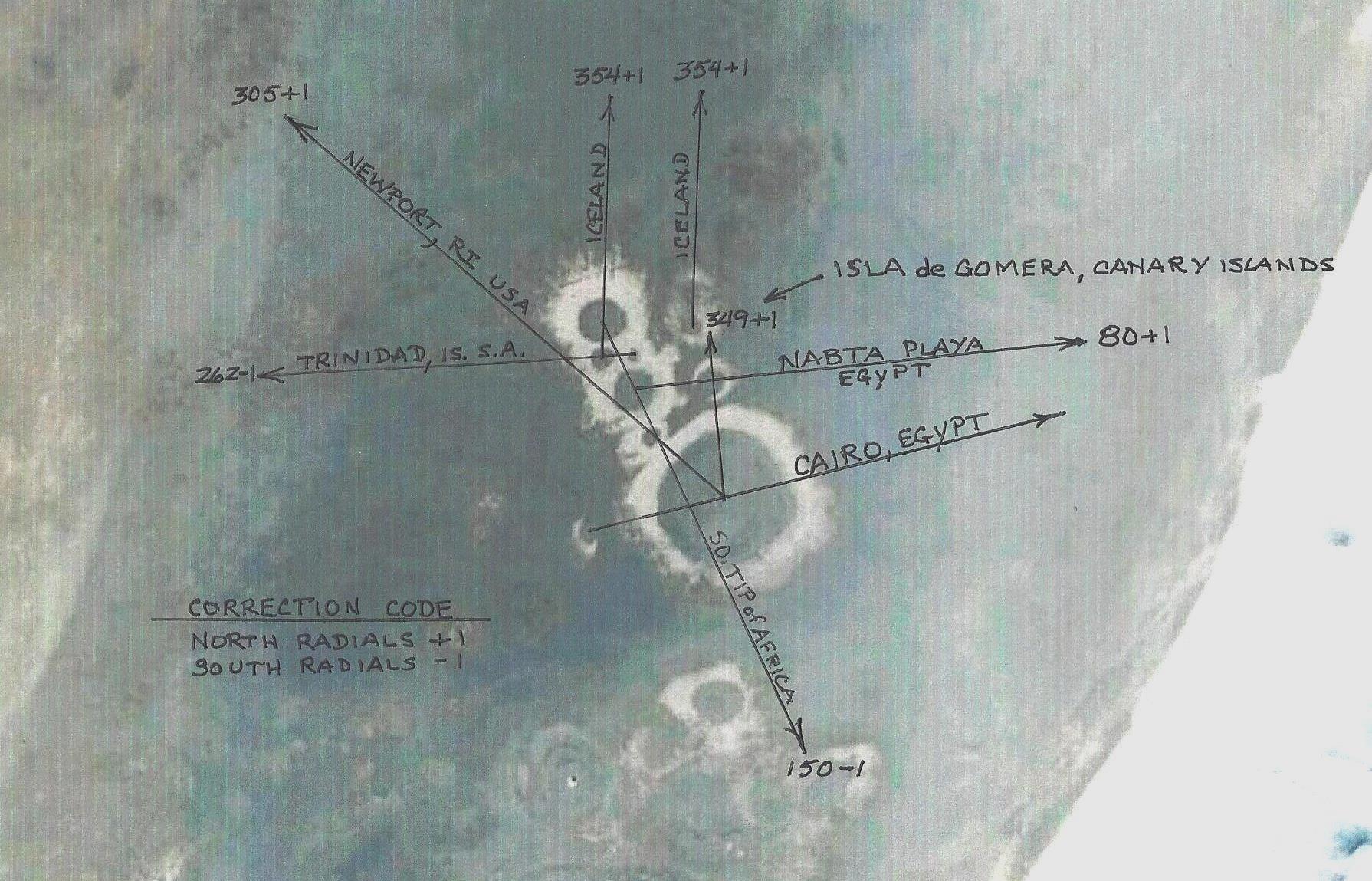
Bearing - A bearing refers to the direction that any line, formed by a geoglyph, points in relation to "Magnetic North". Magnetic North can be used at the geoglyph site because it has not been distorted by deviations that exist between the starting point and the destination. A True or direct line is used once you depart the origination point because as soon as you begin tracing a line away from the source magnetic deviation becomes a factor. Magnetic Deviation exists all over the world and renders the magnetic heading of a compass useless over long distances because of the error occurring naturally from the magnetism of the earth. A true heading is the shortest distance between two points without having to consider magnetic deviation. True headings can be scribed on a globe, derived from Celestial Navigation, GPS, and computer software. These methods only produce True Headings which are not distorted by Magnetic Deviation. It was learned, through Google Earth, that all the magnetic bearings used in Ancient Geoglyphs, at the source, proved to be true radials once you leave the origination source.
Radials - Radials are bearings after they leave the source. At the source Magnetic Bearings and True Headings are the same because no distortion has taken place by moving away from the source. Once a direction away from the source is plotted it must be plotted on a true course (straight line), not a magnetic course, in order to avoid magnetic deviation.

Geoglyphs, for the most part, are so large that they can only be recognized from the air. The civilizations that placed these geoglyphs must have had mathematical capabilities well beyond anything we give them credit for. I have visited some sites on the ground and even knowing they are there I find them difficult to locate. The glyphs take on several forms. Some take the form of a triangle, another might be one or more circles, and another may be one or more lines touching or crossing each other. No matter what shape a glyph takes, any line can be a pointer to a place important to the creator of that glyph.
After applying the linier criteria, by projecting the lines and angles built into the geoglyph, it is then necessary to apply certain secret protocols to the linier extensions to determine where the extensions terminate. These protocols allow the user to determine the destination and stopping point of the bearings emanating from the geoglyph.
Once the bearings are established for a geoglyph, the bearings are extended in the form of radials (True bearings) to determine if, and where, they intersect with an object that meets the ancient protocols established millennia ago. In order for an extended radial to be considered legitimate, a radial must intersect a specific point which meets the criteria set down by the ancients. These points verify that the radial is legitimate and indicate the endpoint of the radial. A few examples of termination points are: the mouth of a river, another geoglyph, a monument, a location sacred to the culture that built the geoglyph and validated by being identified by another geoglyph, the entrance to a bay, a significant protrusion on a land mass such as the corner or tip of a continent, the tip of a peninsula, or an island. The tip of the highest mountain in a certain area could also be used.
After some study it was discovered that many mediums were used to construct geoglyphs. These included the arrangement of stones, the planting of different colors of flora, and the sterilizing of the ground, the scraping of the earth to reveal a different color underneath (Nazca), the changing of natural geological features with the features modified or supplemented, the wall alignment of structures (Caral, Peru), the alignment of Monoliths (Stonehenge), the alignment of Pyramids (Worldwide), the creation of stone and earth mounds, and more. For instance, the edges of the mounds of the Mississippian Indians (Mound Culture), in the central United States have been proven to be geoglyphic territorial pointers.
Ancient archeological locations, many previously unknown, have been identified through Geoglyphology. The accuracy of the calculations of the ancient peoples is incredible. The GPS accuracy of the modern software program is seldom more accurate than the orientations of the ancients. By calculating the bearing at the source one can follow the extended radial for sometimes thousands of miles and locate a related geoglyph with little or no error.
The percentage of success in locating a verifiable glyph or ancient location using each of the extended radials of any one glyph was variable, but ran in the range of 90% to 100%. Much of the lack of success was attributed to urbanization, overgrowth, vandalism, etc. Surprisingly, based on the glyphs that were found, there seems to be an incredible amount of durability built into the geoglyphs. It appears that the meteorological conditions at any given site were considered in determining the materials used. At sites where rain and wind are seldom seen, most glyphs were made of earth. At locations that encountered rain and wind, stones and rock were used.
Research results indicate that Geoglyphology holds great promise in expanding our understanding of the civilizations that have preceded us. Through the tireless efforts of many devoted archaeologists, and new methods of discovery, the world is on the cusp of a new awakening. To some this new paradigm change will be quite uncomfortable.

Ancient Underwater Geoglyphs - Fongbin China (c8000 BC)
Located by extending one of the radials from the Yonaguni Pyramid.
http://www.yonaguni.ws
Gulfo de Cintra Geoglyphs - West coast of Africa (c7000 BC)
Note: The calculations performed in Geoglyphology require the use of a special software called "Google Earth". Google's software is able to calculate true spherical bearings on the curved surface of the earth and then display them correctly on a flat plane.
Spherical Geometry
In Spherical Geometry there are no parallel lines. It is difficult to grasp the concept that two bearings of the same value can cross. That is because we are used to thinking in terms of Plane Geometry on a flat plane. However, all this changes when you draw lines on a sphere. In dealing with a sphere you enter the realm of Spherical Geometry.
Spherical Geometry is the study of figures on the surface of a sphere, as opposed to the type of geometry studied in Plane Geometry or Solid Geometry. In Spherical Geometry, straight lines are great circles; therefore, any two lines will always cross in two places somewhere on the sphere. A good example of this is to look at a globe of the earth. The Longitudinal lines cross at two places, the North and South Poles, however; the Latitudes never cross. That is because the Latitudes are an example of Plane Geometry slicing through the earth, while the Longitude is an example of Spherical Geometry when a line is drawn on the surface of the earth. An accomplished mathematician, as were the ancients, can use a line to point to a distant object, or use two lines to come together at a distant point to highlight an important place.
In the field of Geoglyphology, we are plotting lines in a spherical world and then displaying the results on a flat plane. It is difficult to grasp the concept of combining Spherical Geometry with Plane Geometry. That is why the new field of modern Geoglyphology could not have been proposed without the advent of the "Google Earth" software that computes using Spherical Geometry which then displays the results on a flat plane. This type of precise mapping precludes the plotting of these bearings on a flat map. Maps become distorted when converted from a sphere to a flat map. Any lines that are depicted in this article on a flat, satellite map were first plotted using the software and then drawn on the flat map after the end points were determined. Even then, the proper curvature is missing. The compelling question is; what knowledge did the ancients possess that allowed them to do these calculations. The most likely answer is their knowledge of the earth and obsession with astronomy.
|
This book exposes ancient secrets, which have hidden for thousands of years by secret societies. The author's discovery of an ancient science, which outlines the ancient territories and migrations of cultures going back thousands of years, makes this book possible. The presentation of this information, through photographic evidence, greatly simplifies the process of understanding the points that the author presents. The non-technical portion of the book is the result of years of intensive research. This research, for the first time, brings together the bits and pieces of existing historical documentation to chronicle a story, of the pre-Columbian colonization of the Americas, that has been concealed for centuries. I would highly recommend this book to anyone who is interested in the true story of Columbus and the pre-columbian colonization of North and South America by the Europeans. Click to order "La Merica" in the US Click here to order "La Merica" in the UK |