"The Nazca Star"
Nazca Peru
Recently many, previously unknown, geoglyphs have been found in proximity to previously recognized
and published Nazca Lines. These new discoveries were published in periodicals around the world.
Archaeologists discover new geoglyphs near Nazca Lines in Peru
PALPA, Peru (Reuters) - "Archaeologists using drones have discovered more than 25 geoglyphs etched into
a swath of coastal desert in southern Peru near the Nazca Lines, a culture ministry official said Monday. ..."
Reuters News Network - 5/29/2018 by the Reuters Staff
Nazca Lines SHOCK discovery:
25 mysterious new glyphs found
- but WHO left them?
"The Nazca Lines in Peru stunned archaeologists again this week after more than 25 new glyphs
were found in the ancient Nazca Desert. But who left these mysterious lines the ground? ..."
Daily Express News - 6/1/2018 by Sebastian Kettley
The Nazca Lines are a series of large ancient geoglyphs in the Nazca Desert, in southern Peru. Some of the figures are up to 1,200 feet long.
Scholars believe the Nazca Lines were created by the Nazca culture between 500 BCE and 500 CE. Most are simple straight lines, others form
geometric shapes. Many are zoomorphic designs of animals and human figures. The designs are shallow lines made in the ground by scraping
away naturally occurring reddish pebbles exposing the whitish ground beneath. Due to the dry, windless climate of the plateau, the lines have
been preserved naturally.
The lines and figures can be seen from an aircraft, from the surrounding foothills, and other high places. Most scholars agree that the designs
were created by the Nazca Culture; however, at this point most scientists disagree on who engineered the lines or why they were constructed.
In addition to the other geoglyphs which have been recently found there is one which has been hiding in plain sight. That geoglyph has been
named the Nazca Star.
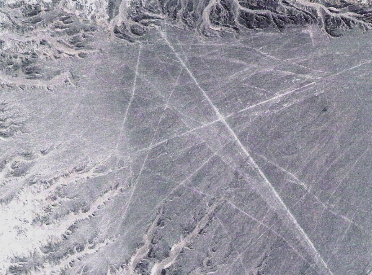
THE NAZCA STAR
Nazca Star in Relation to Previously Recognized Lines
Nazca Star Highlighted
Nazca Star Projected Endpoints
The endpoints were determined using Google Earth and the protocols
contained within the ancient Science of Geoglyphology.
Nazca Hummingbird Bearings
In the previous image you see the iconic Nazca Hummingbird geoglyph. Using the ancient science of Geoglyphology the Hummingbird geoglyph
was also found to be a Geoglyphological survey marker. This can be proven by determining the orientation of the radials, using Google earth, and
extending them using the protocols established in the ancient science of Geoglyphology. Not by coincidence, both the Nazca Star and the Humming
-bird geoglyphs display the 292 degree bearing. The 292 degree radial points to Hawaii. The other bearings displayed by the Hummingbird geoglyph
point to other important landmarks. These same landmarks are used frequently, around the world, to establish other territorial boundaries. The 025
degree radial of the Hummingbird geoglyph points to the Faroe Islands. The Faroe Islands played a major role in Celtic and Norse history. Since this
image was made public the Hummingbird has been blurred out, on Google earth, and a hand drawn image placed over it, which may or may not be
accurate.
You must be wondering how the Pacific Islands of Hawaii, Fiji and New Zealand figure into the territory that is outlined by the Nazca Star geoglyph.
Geoglyphs, around the world, point out Hawaii as the dividing point between the territory claimed by ancient Japan and the territory claimed by the
ancient Celts, Portuguese, Etruscans, Phoenicians and their predecessors.
Map of Polynesia
This map shows the ancient territory known as Polynesia. If you will notice, three of the end points described by the Nazca Star Geoglyph coincide
with the western boundary of the Polynesian Territory. The Polynesian boundary exists just outside the ancient Japanese boundary described at:
http://www.yonaguni.ws. It should also be noted that the enigmatic Easter Island completes the triangle known as the Polynesian Territory. The
following geoglyph, as well as the Yonaguni Geoglyph/Pyramid and many others in Japan, also describe the ancient territory claimed by Japan.
THE ANCIENT JAPANESE TERRITORY
Ancient Japanese Territory
As defined by the Yonaguni Pyramid c8000BC.
http://www.yonaguni.ws
Japanese Keyhole Like Geoglyph
This territorial geoglyph, like the Yonaguni Pyramid, is located in Japan. Both geoglyphs
designate a territory, constructed in different time periods, which were claimed by ancient
Japan. (NOTE: The ancients used some type of chemical on the floura to preserve these
geoglyphs. This occurs all over the world.
Geoglyph Bearings
(NOTE: The original survey was conducted at much higher magnification. All bearings are not displayed in this image.)
Japanese Geoglyph Endpoints (West Side)
Japanese Geoglyph Endpoints (East Side)
As you can see, the area claimed by Japan was expanded between the time the Yonaguni Pyramid was cut and the time this geoglyph was laid out.
It appears that Australia and some Middle Eastern land was added. What is important to note is that the western endpoints of Hawaii, Fiji and New
Zealand, in the Japanese Territory, match the same endpoints in the Nazca Star geoglyph. This, and similars findings, bears out our research which
shows that the earth, at some time in the past, was divided up into territories. These territories existed all over the world and fit together like a giant
jigsaw puzzle. It should be noted that many of the ancient territorial geoglyphs still designate the boundaries of modern countries.
Japanese/Nazca Star Geoglyph Endpoints
Territory Attacked or Held by the Japanese in WWII
This Map designates the territory which the Japanese were attempting to reclaim in WWII. The territory matches the territorial claim as stated in
the Yonaguni Pyramid Geoglyph. As we all know Hawaii, the eastern most point in the ancient Japanese territory and the western most point in
the Nazca Star geoglyph territory was attacked by Japan but not captured. This fact seems to validate the ancient Japanese claim demonstrated by
the Yonaguni Pyramid. The Japanese also attacked Attu Island in Alaska. Attu Island, the northern most point depicted in the Yonaguni Territory,
has no resources. Why would the Japanese attack a worthless island far away from their homeland? Can all these circumstances be coincidental?
EUROPEAN PRESENCE in the AMERICAS
Research has shown that ports currently known as Lisbon, Portugal, Vera Cruz, Mexico and Buenos Aires, Brazil all played an important part in the
ancient history in the Atlantic. The Nazca Star makes reference to all three of the ancient ports. Vera Cruz is recognized as the port serving Mexico
City.
Historians agree that Portugal and their predecessors, at one time, held a dominant nautical position in the Atlantic Ocean. Can the obvious references
to ancient places currently held by the Portuguese indicate a pre-Columbian presence in the Americas? In the Juan de la Cosa Map, of 1500CE, survey
markers are denoted by a dot within a circle at the head of all the major rivers in South America and southern North America.
Placing a survey marker at the head of a river was the way explorers claimed the land bordering the river. Could all the rivers in South America and
southern North America have been explored in the 8 years between 1492CE, when Columbus reportedly discovered the Americas and 1500CE when
the map was drawn?
The Juan de la Cosa Map of 1500CE
The geoglyphs and associated rivers, which appear on the Juan de la Cosa Map,
have been highlighted for better visibility. The geoglyphs appear on the map as
a dot within a circle. A satellite photo of each survey marker can be found in
the book "Ancient Signposts" available on Amazon.
It is interesting that Juan de la Cosa, a Galician and the author of the previous map, was also the owner and navigator of the Santa Maria on
which Columbus made his first voyage to the Americas. Juan's navigation took Columbus's fleet to the precise eastern point where ancient
geoglyphs indicate that the border of the ancient Mesoamerican and North American territories met.
It is a well-known fact that the crew of the Santa Maria was considering mutiny three days before they reached their destination. How did Alonso
Pinzon, Captain of the Pinta, know to tell the crew that if they did not reach land within three days they would turn back? They reached land on
the third day. History tells us that at the same time they made a course correction. Why would they make a course correction unless they already
had a map showing their destination? There currently exist territorial survey markers (geoglyphs) near the point where Columbus landed. These
survey markers outline the territory in the Caribbean and Mesoamerica which was claimed for Spain.
Terra Brasilis Map of 1519
This map depicts the East coast of South America, north of the Amazon River. Notice the Templar ships on the map. The Templars fought for
Portugal, with Spain, against the Moors under their new name of "The Order of Christ". The Moors occupation of Iberia spanned the years
711CE-1492CE; however, the push by Portugal and Spain to rid Iberia of the Moors did not begin until the Templars met their demise in Europe
in 1312CE. This map is just one more sign that the Portuguese and Templars were in the Americas prior to Columbus.
(See: the book "La Merica" - 2014.)
The Amerigo Vaspucci Map of 1507CE
It would be interesting to know how Alaska, and the associated Pacific islands, appeared on a map made in 1507CE. One would have to assume
that the west coast of North and South America had been explored prior to 1507CE. Historical records tell us that Russia and Japan fought over
Alaska thousands of years ago. You may have noticed that a pointer to Alaska, which existed in the Yonaguni territorial map, is missing in the
map of the later Japanese Keyhole geoglyph. This transition coinsides with Japanese history. Maps which show previous habitation in the
Americas suddenly appear c1500CE, after the voyage of Columbus. The creators of many maps did not know at the time that they were
not supposed to include pre-Columbian exploration on their maps.
If Europeans were in ancient America it would be logical that they would lay claim to their territory by placing a survey marker there. One of those
markers would appear to be the Nazca Star.
by Arthur Faram
The Faram Research Foundation
CONCLUSIONS:
The Nazca Star is a newly discovered geoglyph, validated by similar geoglyphs around the world.
The Nazca Star and other Nazca geoglyphs have unique properties which can be validated by the protocols contained in the ancient science of Geoglyphology.
The endpoints pointed out by the Nazca Star seem to have a logical place in ancient history.
The endpoints established by the Nazca Star, other geoglyphs, and evidence from around the world, seems to point in the direction of a culture with sophisticated navigational skills, which has existed throughout history.
Research has shown that the entire world was mapped out at one time with territories which adjoin one another, just as in the case of the Nazca Star and the Yonaguni Pyramid.
The Vikings and Templars in America.
Click here to preview or purchase.
IMAGE CREDITS:
All maps courtesy of Wikipedia Commons
All images by The Faram Research Foundation.
REFERENCES:
The Secret History of the Templars in America
- by Tim Wallace-Murphy and Merilyn Hopkins 2004
Templar Survival in Portugal
by The Duke of Barcelos
Ancient Signposts
- 2011 by Arthur Faram
La Merica
Foundation Press - 2014 by Arthur Faram
http://www.livescience.com/50698-nazca-lines-images.html
http://www.whodiscoveredit.com/who-discovered-alaska.html
http://www.thefaramfoundation.com/medicinehatcanada.htm
http://www.yonaguni.ws
http://www.thekensingtonrunestone.com
http://www.thefaramfoundation.com
Google search: Nazca Lines
Google search: Templars in America
Wikipedia search: Nazca Lines
Wikipedia search: Templars in America
© 2018 The Faram Research Foundation
(This article may be republished, if published in its entirety with proper accreditation.)