This paper details the results of a geoglyphical study of the newly discovered Bosnian Pyramids, located at Visoko, Bosnia, discovered by Dr. Samir Osmanigic in 2005. The practice of using the geometry of ancient structures to release hidden details of their origins is not a new practice. This practice has been handed down through secret societies since even before the building of the Bosnian pyramids. I call the re-discovery and application of this ancient practice Geoglyphology. Geoglyphology allows the depiction of ancient territories by using the angles which were geometricly built into ancient monuments and geoglyphs. The endpoint of the extended lines, determined from the angles in the geoglyph, is determined by protocols developed by the ancients.
The function of Geoglyphology, as it relates to Archaeology, is to expand both the search area and the knowledge base available to the Archaeologist. Until now the majority of the information available to the Archaeologist is gleaned from the information recovered at the dig site. In recent years it has been discovered that a great majority of the ancient architectural, monolithic and geoglyphic structures built around the world have something in common. That commonality is that the structures were aligned in such a manner that the study of their linier alignment unveils a much larger story and immensely expands the data available to the archaeologist and the related disciplines.
Data recovered from sites that included Geoglyphology in their study included; Obtaining the geographical range of the culture being studied, the level of sophistication that existed in relation to their understanding of mathematics and geometry, their knowledge of world geography, the discovery of other archaeological sites that were unknown prior to the studies, and the dating of the culture itself from the data collected at related offsite locations identified by the alignments at the dig site. The success of these studies shows that Geoglyphology can play a major role in expanding the knowledge base available to the Archaeologist.
Spherical Geometry
It is difficult to grasp the concept that two, seemingly parallel, 180 degree headings can cross. That is because we are used to thinking in terms of Plane Geometry on a flat plane. However, all this changes when you draw lines on a sphere. In dealing with a sphere you enter the realm of Spherical Geometry. In Spherical Geometry there are no parallel lines. For example the longitudes that you see on a globe were determined using Spherical geometry. These lines were drawn on the surface of the sphere. they all represent great circles, they all cross in two places, the north and south poles, and none are parallel. The latitudes depicted on a globe represents plane geometry as the plane slices through the earth causing parallel lines.
Spherical Geometry is the study of figures on the surface of a sphere, as opposed to the type of geometry studied in plane geometry or solid geometry. In spherical geometry, straight lines are great circles, therefor any two lines will always cross in two places somewhere on the sphere. An acomplished mathamatician, as were the ancients, can use a line to point to a distant object, or use two lines to come together at a distant point to highlight an important place to the builder, or three lines to make a triangle. The angle between two lines in spherical geometry is the angle between the corresponding great circles. A spherical triangle is formed using three great circle lines and is defined by its three angles.
In the field of Geoglyphology, we are plotting lines in a spherical world and then displaying the results on a flat plane. It is difficult to grasp the concept of combining Spherical Geometry with Plane Geometry. That is why the new field of Geoglyphology could not have been proposed without the advent of software that computes using Spherical Geometry, which then displays the results on a flat plane. This type of precise mapping precludes the plotting of these bearings on a flat map. Maps become distorted when converted from a sphere to a flat map. Any lines that are depicted in this article were first plotted using spherical software and then drawn on the flat map after the end points were determined. Even then, the proper curvature is missing. The compelling question is; what knowledge did the ancients possess, ions ago, that allowed then to do these calculations.
Note: The calulations performed during the writing of this paper required the use of a special software called "Google Earth". Google's software is able to calculate true spherical bearings on the curved surface of the earth and then display them correctly on a flat plane. The ends of the straight lines that follow were precisly calculated prior to being depicted as straight lines. This means that the curvature that would normally be seen from the curvature of the earth is missing.
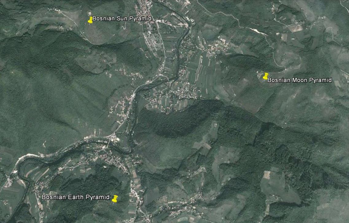
The Three Major Bosnian Pyramids
Stage One
The building of the Pyramid of the Sun
c29000 BC
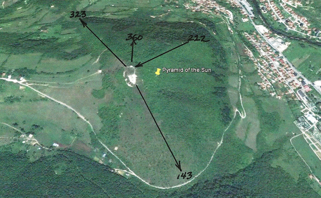
NOTE:The lines drawn on the pyramid edges were determined by a geographic survey of the pyramids.
Bosnian Pyramid of the Sun (c29000 BC)
Bosnian Pyramid of the Sun Radials (Edges only)
NOTE: The pyramid radials depicted in this survey were taken from either the edges built into the pyramids or from the base of the pyramid.
The radials for any structures were determined from the alignment of the walls or other geoglyphic protocols established by the ancients.
Bosnian Pyramid of the Sun Radials
(The four additional radials resulted from adding the four cardinal points of the compass, as determined from the base of the pyramid. The endpoints of the radials were determined by using the protocols established by the ancients. These radial endpoints depict the territory claimed by the builders of the Bosnian Pyramids in 29000 BC. As time progressed the boundarys changed, resulting in the need to build more pyramids (Survey markers). Territorial marking is not the only function of the pyramids. However it is a function built into every major pyramid on earth.)
Stage Two
The Building of the Pyramids of the Moon and the Dragon
c9500 BC
Bosnian Pyramid of the Moon (c9500 BC)
Bosnian Pyramid of the Dragon (c9500 BC)
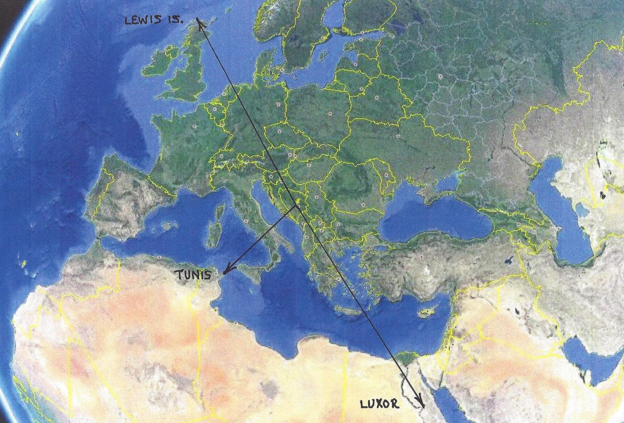
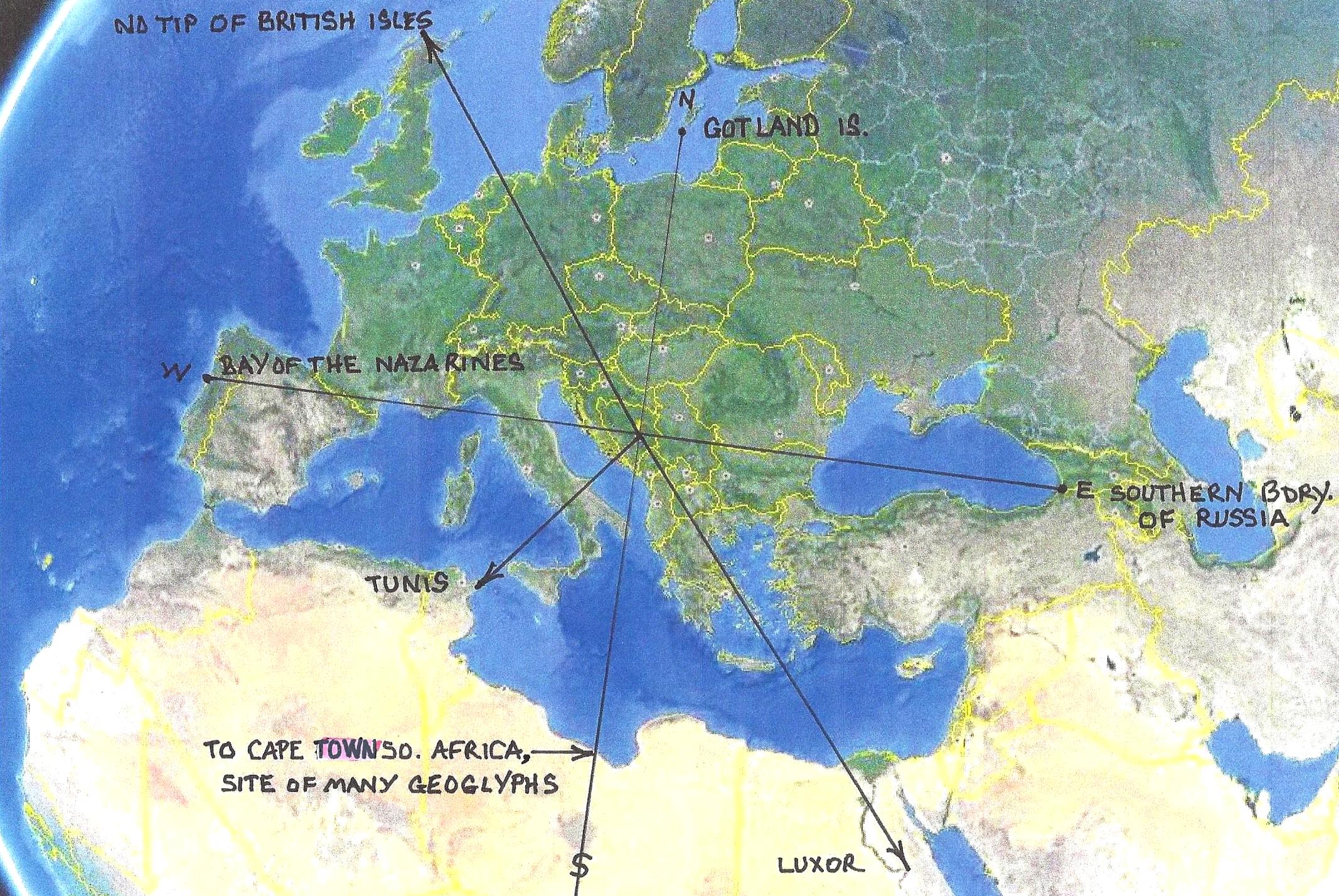
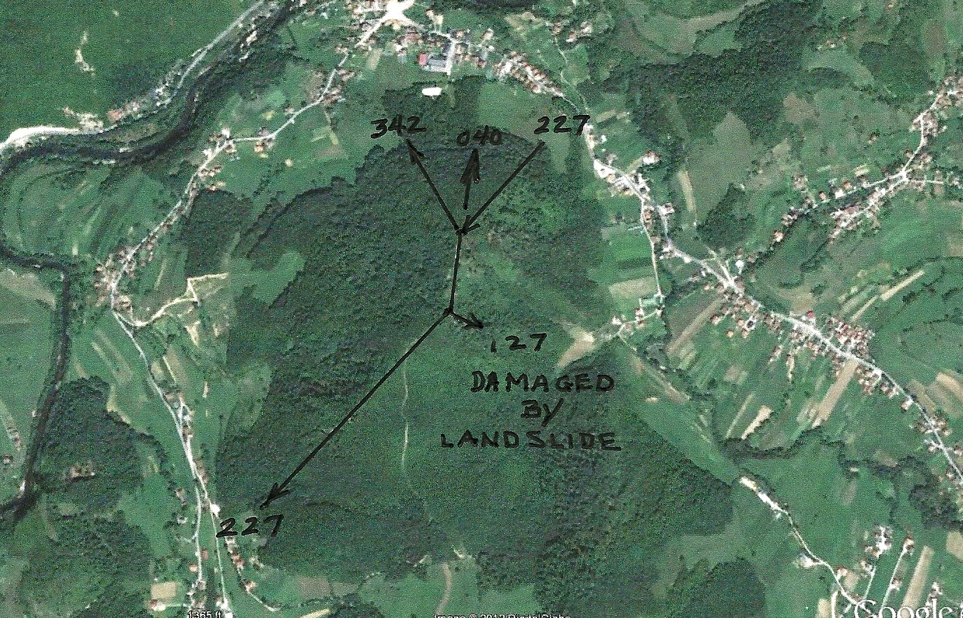
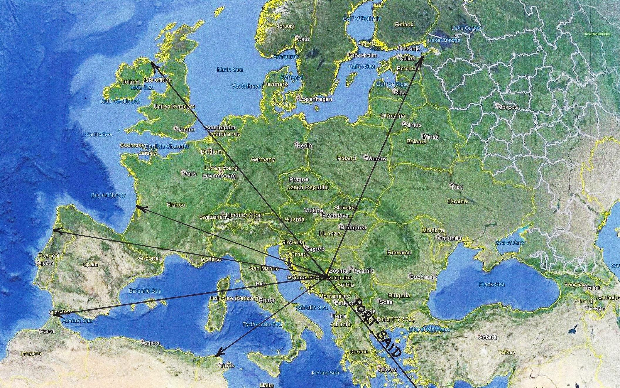
Radials, Territory and Important Points, Defined by the Three Bosnian Pyramid Radials. c29000 BC - c9500 BC
(As is true of many major geoglyphs, the endpoints of the radials, although not readily apparent, point to important historical locations.)
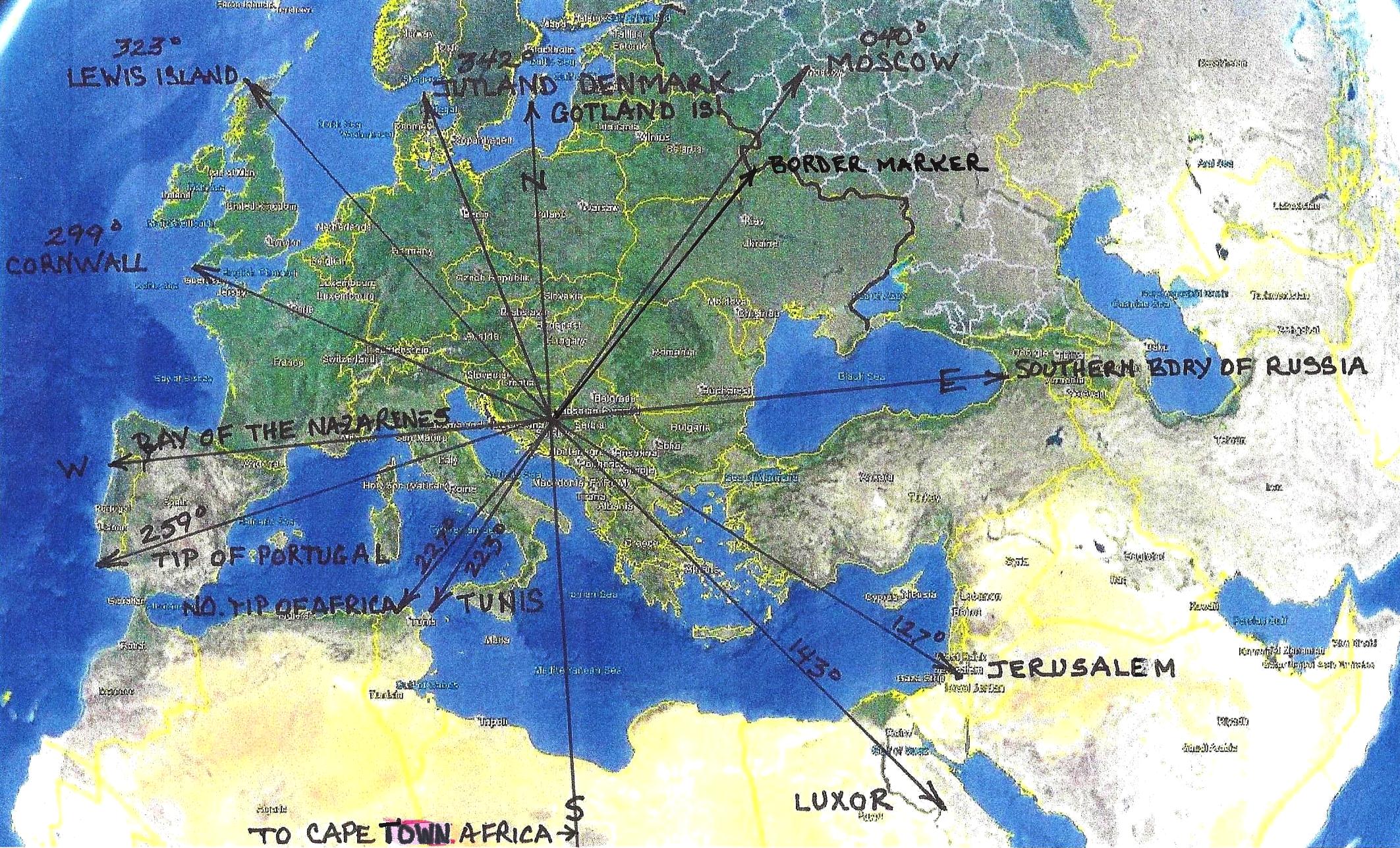
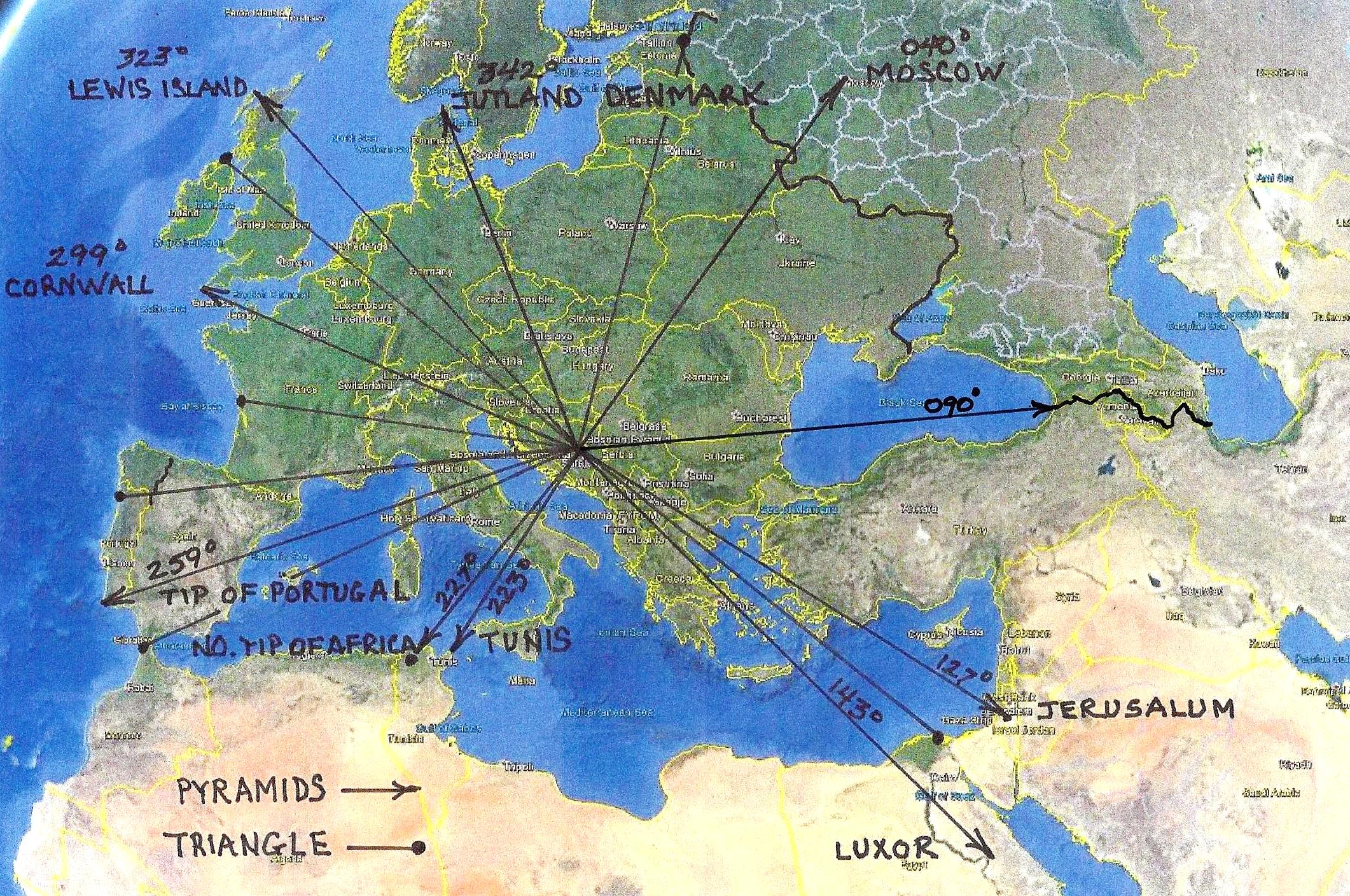
Endpoints for the bearings displayed in the above photo.
040 Degree Radial - Moscow - Location of the survey marker (Geoglyph) for the adjacent territory.
090 Degree Radial - Southern Boundary of Russia
127 Degree Radial - Jerusalum
143 Degree Radial - Luxor, the spiritual center of the Egyptians.
180 Degree Radial - An important radial in any geoglyph, terminating in an Ancient Geoglyph, in Cape Town South Africa
223 Degree Radial - Tunis, Tunisia
227 Degree Radial - Northern Most Point in Africa (Africa's ancient name was Libya)
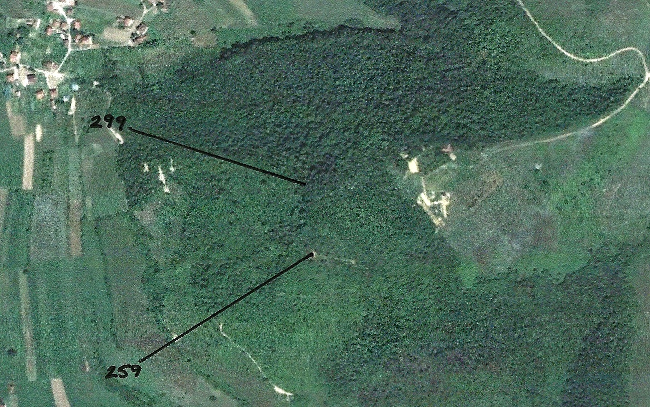
259 Degree Radial - Southernmost point in Portugal as well as the Island of Medeira in the Atlantic
299 Degree Radial - Southernmost Point in England
270 Degree Radial - Bay of the Nazarenes. Sacred location that became a refuge for Orthodox Christians, after the establishment of the Catholic Church.
323 Degree Radial - Northernmost Point in Scotland
342 Degree Radial - Southern Tip of Alaska (Widely used in ancient times as a reference point for the geometry of Pacific territories.)
360 Degree Radial - Gotland Island. This Island has had a special place throughout history.
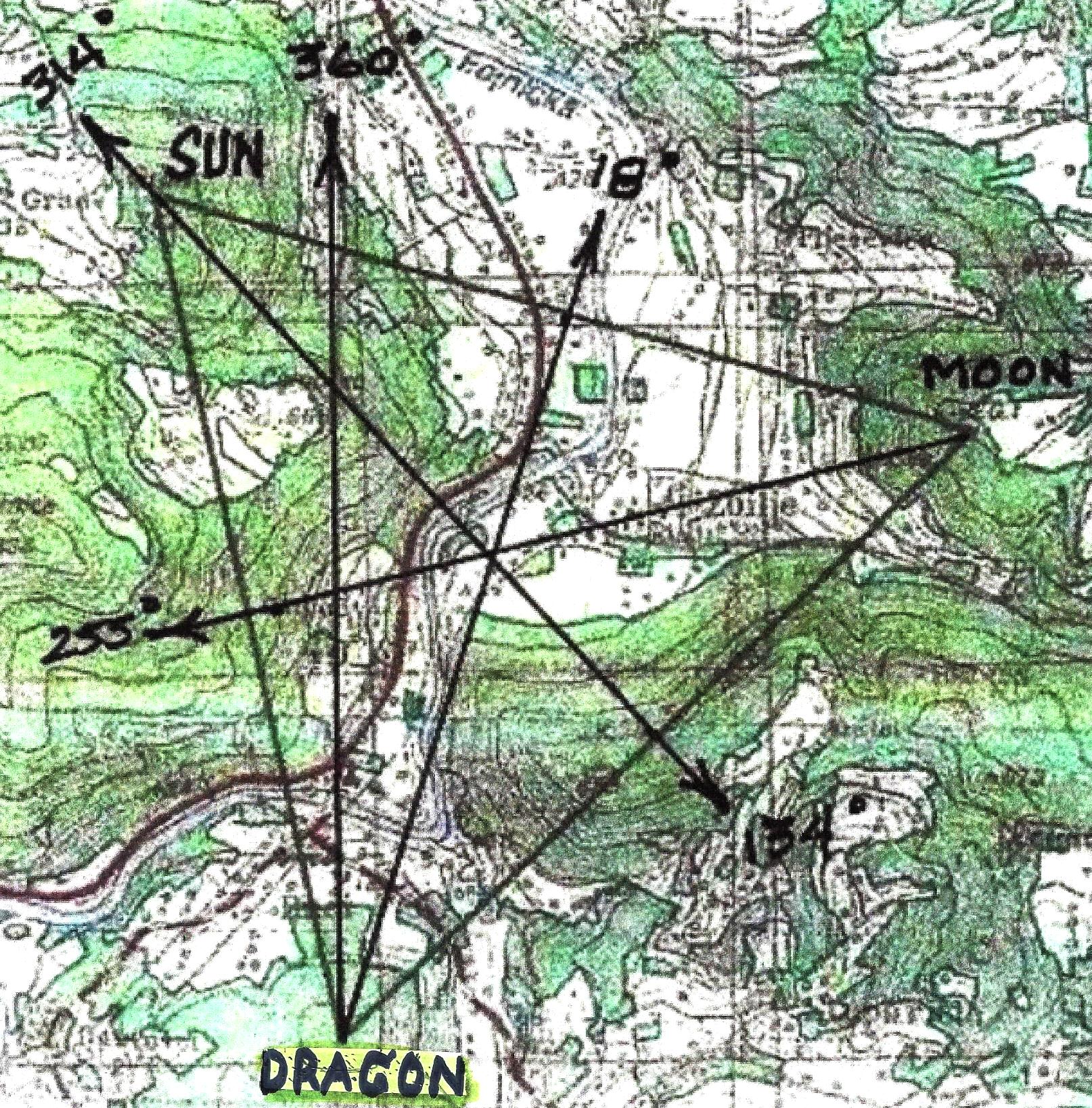
The Pyramid Triangle
c9500 BC
The Triangle Created by the Three Main Bosnian Pyramids
(With resulting radials displayed)
The Radials Created by the Bosnian Triangle
These radials were created when the pyramids of the Moon and Dragon (c9500BC)
were combined with the radials of the pyramid of the Sun (c29000 BC).
Combined Radials of the Bosnian Pyramids and the Bosnian Triangle (c29000 BC to c9500 BC)
This study indicates that what is now called the Russian/European border was already established by the time the Moon and Earth Pyramids were built, c9500 BC. The
Russian Survey Marker (Geoglyph) has been located and surveyed. It matches perfectly with the Visoko Pyramid boundaries. The 040 degree radial, which extends outside the European boundary, points out Moskow, the site of the geoglyph that denotes the adjacent territory. Most ancient geoglyphs point out the survey marker for the adjacent territory.
The Bosnian pyramids appear to be early, post-apocolyptic, geometric structures. The geoglyphs that were constructed atop two of the pyramids, most likely during the middle ages, more clearly define the territory that has been discussed previously. The reference to the Pacific Territories (Southern tip of Alaska), in both the pyramid geometry and the geoglyph geometry, indicates a knowledge of, and a relationship with, the Pacific cultures, and territories, of the time.
Stage Three
The Structural Geoglyphs Built on Top of the Bosnian Pyramids
c1300-1500 AD
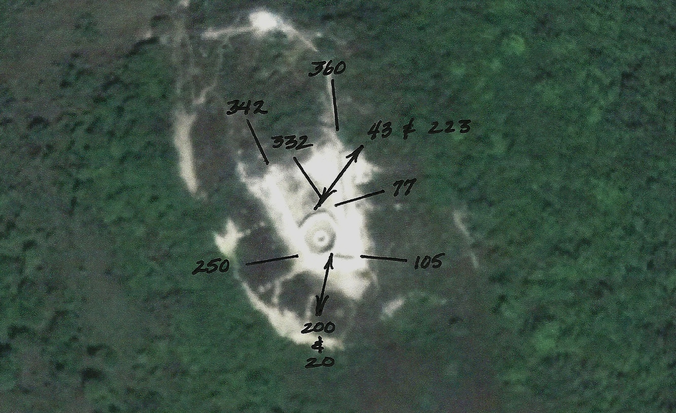
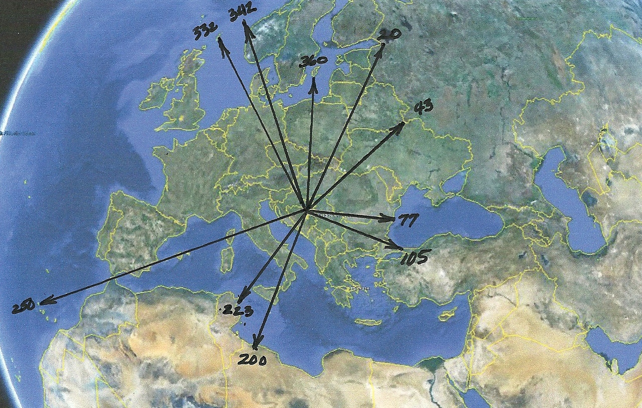
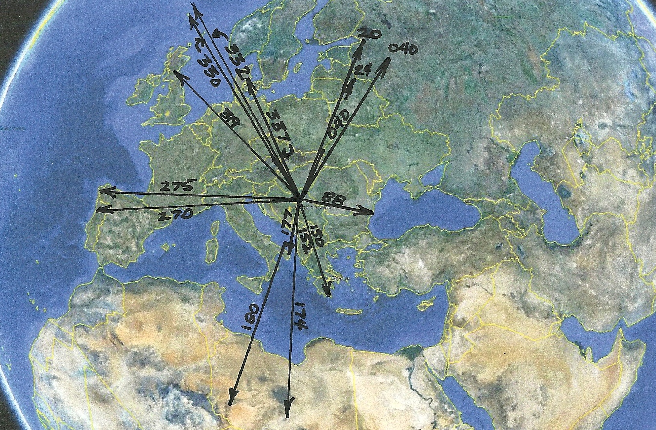
Bearings Associated with the Geoglyph on top the Sun Pyramid (c1400)
Radials Associated with the Geoglyph on top the Sun Pyramid
Endpoints for the bearings displayed in the above photo.
020 Degree Radial - Saint Petersburg, Russia
043 Degree Radial - Intersection of the Border Between Balarus, Ukraine, and Romainia
077 Degree Radial - Mouth of the Danube River and Boundary Between Ukraine and Romania.
105 Degree Radial - Entrance to the Black Sea North of Istanbul.
200 Degree Radial - Tripoli, Libya
223 Degree Radial - Tunis, Tunisia
250 Degree Radial - The Canary Islands.
332 Degree Radial - Northern Tip of Shetland Island
342 Degree Radial - Southern Tip of Alaska. (A key point in the Geometry of the Pacific Territories.)
360 Degree Radial - Southern Tip of Gotland Island. (An island of spiritual mystery down through time.)
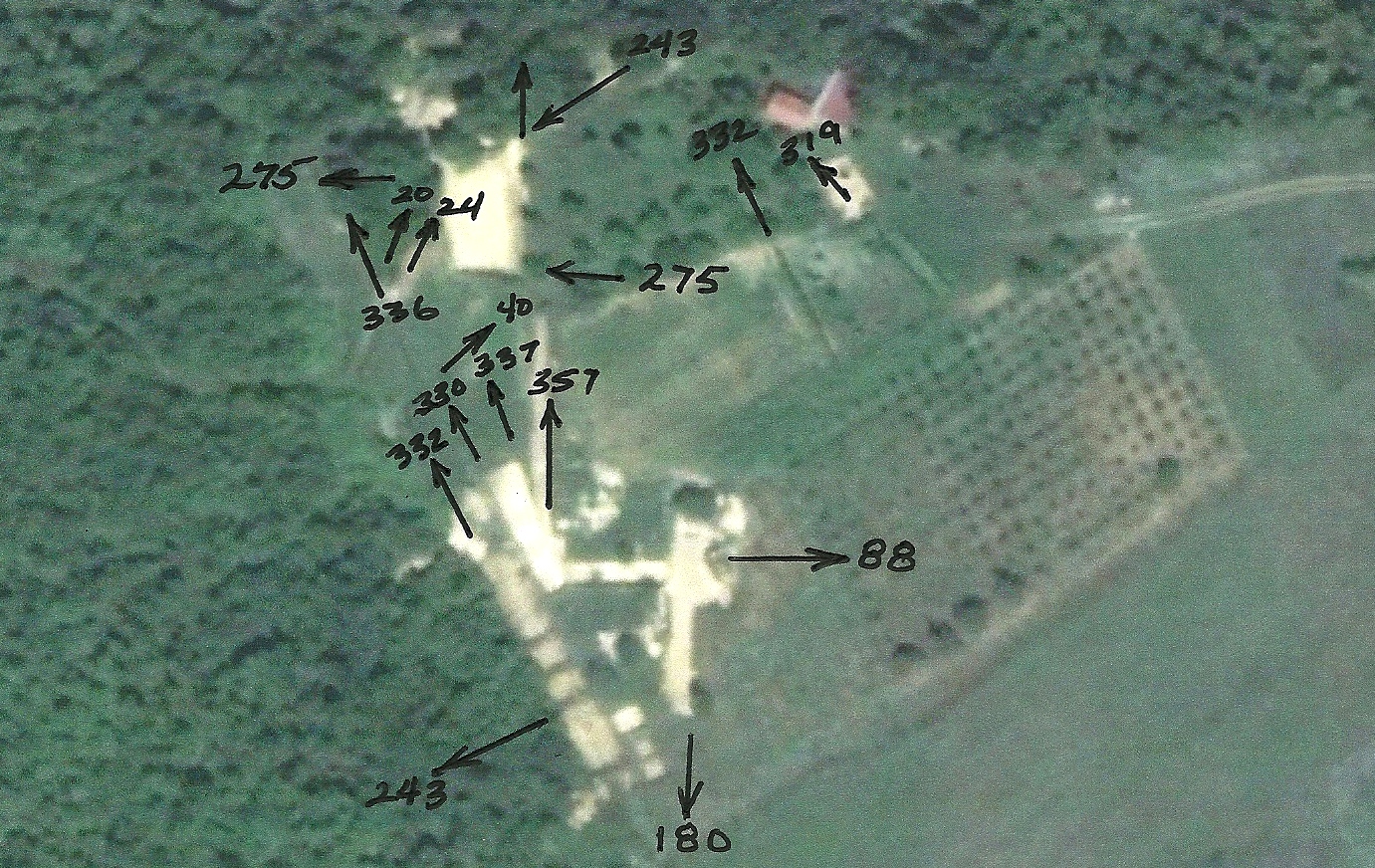
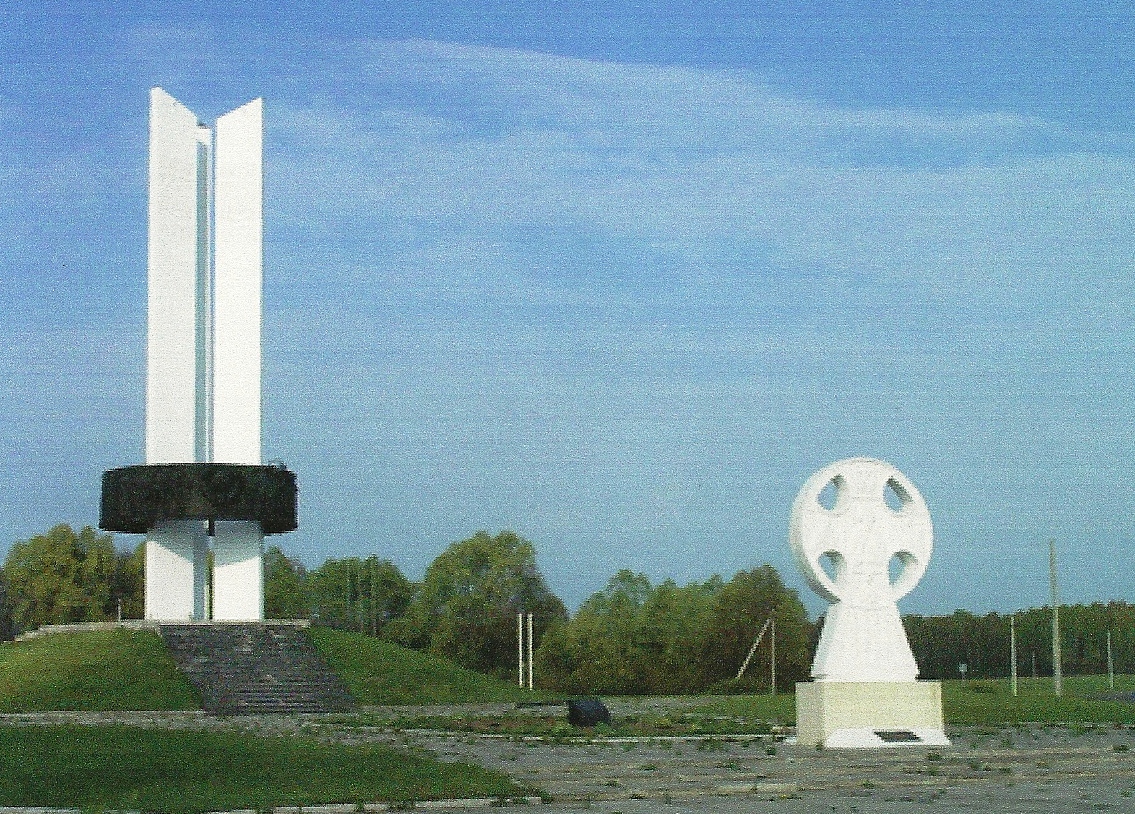
Bearings Associated with the Geoglyph on top of the Moon Pyramid
Radials Associated with the Geoglyph on top of the Moon Pyramid
Endpoints for the bearings displayed in the above photo.
020 Degree Radial - Saint Petersburg, Russia
024 Degree Radial - The intersection of the borders, of what is now, Russia, Latvia and Belarus.
040 Degree Radial - Moscow - Location of the survey marker for the adjacent territory.
088 Degree Radial - Where the Danube River enters the Black Sea.
150 Degree Radial - Northern tip of the Thermaic Gulf, Greece
152 Degree Radial - The western tip of the Island of Crete
174 Degree Radial - Johannesburg, South Africa - Location of many geoglyphs.
177 Degree Radial - SE tip of Italy
180 Degree Radial - An important radial for Geoglyphological reasons, which terminates in an ancient concrete geoglyph.
270 Degree Radial - An important radial for religious reasons, which terminates at the Bay of the Nazarines, the first followers of Jesus.
275 Degree Radial - Corunia, Galicia (Now part of Spain) - Headquarters for the Celts from c400 BC - c700 AD
330 Degree Radial - Faroe Islands
319 Degree Radial - Edinburg, Scotland - Later headquarters for the Celts, under the Sinclairs.
332 Degree Radial - Entrance to the Elbe River, gateway to Hamburg, Germany.
337 Degree Radial - The Southern tip of Norway.
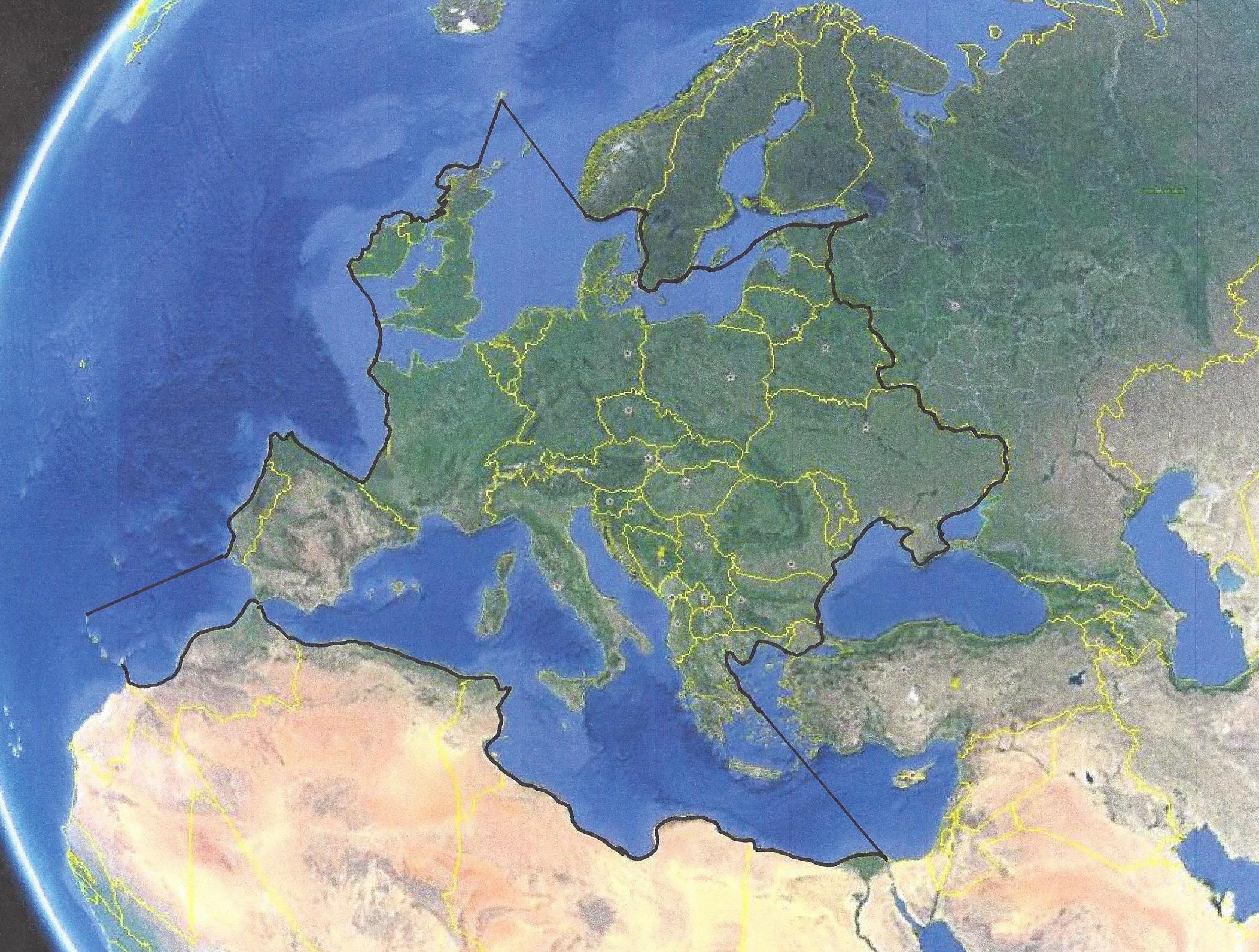
The territory defined by the additions and revisions completed since the Sun Pyramid was constructed c29000.
(c29000BC - 1400 AD)
The historical record tells us that the Celts once covered the entire continent of Europe.
It is possible to see, from the previous map, and history, that the Celts were forced west
by warring tribes until they occupied only the western territory of Europe, the territory
that we commonly think of as Celtic in modern times. The Bosnian territorial markers
either in part or in their entireity most likely involved the Celts. The original territory
contained both Europe and Africa. The final territory ended with what we now know
as Europe. Many other Contental territories, throughout the world, were defined in the
same way.
CONCLUSIONS
The Bosnian Pyramids, are unique in that they seem to point out locations and cities which have become spiritually and historicly important to many cultures. The Bosnian Pyramids are less symetrical, and are of a cruder construction, than most of their counterparts. This is also true of the Indonesian Pyramids on Java Indonesia, whose construction, and age, is very similar to the Bosnian pyramids.This crudness alone could indicated a culture that is recovering from a catastrophe that left them with their past knowledge but without the tools to excercise that knowledge effectively. The increasing sophistication of pyramids which follow this era, leading up to the Egyptian era, would seem to confirm this hypothsis. Conversly, the non-physical attributes of the Bosnian Pyramids would seem to indicate a culture with a superior knowledge of physics.
History tells us that the Celts once occupied what is now called Europe. Recent research indicates that the geoglyphs placed atop the bosnian pyramids, long after they were constructed, are Celtic in nature. History also tells us that the Celtic culture developed in the Middle East and progressed west to the English Channel. A timeline of the geoglyphs atop the pyramids should be developed from an archeaological dig.